
tcp PointCloud Editor
Create grid - PCE
10.1 Create Grid
Location
- Ribbon menu
- Modeling
- MODELS
- Create (Create Grid)
Description
This command allows you to create a grid (Digital Elevation Map), from the project's active point clouds. This command will ignore all the points that belongs to a non-triangulable class.
Parameters
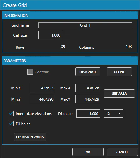
| Name | Meaning |
|---|---|
| Grid Name | Name of the resulting grid. |
| Cell size | Resolution of the grid. Distance between vertices. |
| Contour | Allows to restrict the grid to a user-defined region. |
| Min-Max X-Y-Z | Bounding rectangle of the grid. Restrict the grid to that area |
| Interpolate elevations | If checked, the grid will interpolate the elevations of the grid vertices where there's no point |
| Distance | Only when Interpolate elevations is true, the radius used to find points to interplate the height of a grid's vertex |
| Fill holes | If checked, the grid will attempt to fill all holes (missing vertices) in the grid. This is a preprocess step |
The "EXCLUSION ZONES" button allows to select a set of layers with closed contours (closed polylines). All points contained within those contours will be ignored.
Use cases
-
Computing a Digital Terrain Model (DTM) from a point cloud
-
Computing a Digital Surface Model (DSM) from a point cloud