
tcpTunnel
Points on alignment - TNL5
11.1 Points on Alignment
By entering a Station and Offset and clicking on the Calculate button, the coordinates of the corresponding point are shown on screen, along with the other parameters described below.
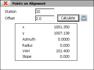
X coordinate of the point.
Y coordinate of the point.
Azimuth of the station entered.
Radius of the station entered.
VAH, vertical alignment height of the station entered. It is only shown if there is a vertical alignment file in the active project. (Sup) sufix indicates that height is calcuted with superelevations (if there is a superelevations file in the active project).
Slope of the vertical alignment in the section to which the station entered belongs. Similarly to the previous data, it is only shown if there is a vertical alignment file in the active project.