
tcpMDT Photovoltaic
Create segments from trackers - PV25
6.1 Create Segments from Trackers
With that command we are going to generate the segments associated with the selected trackers. The segment is an essential file for each tracker as it contains the information of the horizontal and vertical alignments and the longitudinal profile of the surface.
La rasante nominal de cada seguidor se puede calcular por distintos métodos:
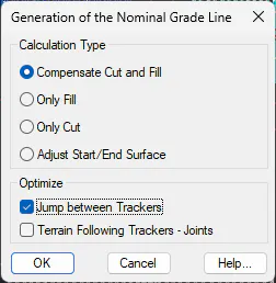
Calculation Type
-
Compensate for Cut and Fill: The grade is calculated, by regression to the longitudinal, which has been obtained from the current surface with the axis of the tracker.
-
Fill only: In this case, the grade is calculated so that the grade is always cleared, but at the same time, generating the minimum clearing.
-
Cut only: The grade is calculated in such a way that it is always on the embankment, but generating the minimum embankment. This option is interesting in the event that we have excavation restrictions.
-
Adjust Start/End Surface: The nominal grade is calculated in a very elementary way, the first and last vertex of the grade takes the height of the surface.
Optimize
-
Jump between Trackers: If this option is enabled, the tracker calculation process will automatically optimize the jump between trackers in the same vertical.
-
Terrain Following Trackers - Joints: If we activate this option, in the case of having articulated or flexible trackers, the process will automatically adjust the maximum drift angle so that it is not higher than the one defined in the Tracker Type.
By executing this option, it will initially request the trackers to which the segment is generated, having the possibility to select the trackers individually, the contents in a zone or all the trackers of the current project.
The name of the segment, as well as each of its components (horizontal and vertical alignments and longitudinal profile) will correspond to the name of the tracker.
These segments will be saved according to the following folder structure:
Project Folder\
Project.dwg Project Drawing
Project.fvv Project File
Terrain.sup Natural terrain of the project
Z01 Zone
Trackers Trackers of the area
Z01-01-01 Files of each tracker
Z01-01-01.eje Horizontal alignment
Z01-01-01.ras Vertical alignment
Z01-01-01.lon Longitudinal profile
Z01-01-01.seg Segment
Z01-01-02
..