
tcpTunnel
Raw data - TNL5
5.9 Raw Data
The program allows one to enable the storing of all information regarding with measured data in an ASCII file. This file is created for each Project and it is stored in its folder with the name LogTS.txt. Each time the file size exceeds 2MB, a new file is created with the name LogTS_N.txt. where N is 1, initially, and its value is increased by 1 unit. For instance, LogTS.txt, LogTS_1.txt, LogTS_2.txt.
The recording of these data is optional, and it can be disabled within Configuration > Options.
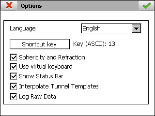
The content of this kind of file is as follow:
File version:
#V 1
Project name:
#Project \ROMDisk\demo\demo.prj
Name of the fields of stored information:
#Date #Time #Code #Option Name ...
Information of the project properties:
*12/11/2015 10:55:16.000 Project properties Sloped profiles: 0
This information is stored when the file is created and, also, every time that project properties screen is validated.
The program stores date and time and the method used for creating tunnel templates.
Measurement data:
12/11/2015 12:51:36.000 _002_ Survey_cross_sections cp1...
-
Date
-
Time
-
Code of the program option
_001_: Survey > Grid
_002_: Survey > Cross-Sections
_003_: Survey > Points
_004_: Checking > Cross-Sections
_005_: Setting Out > Front
_006_: Setting Out > Cross-Sections
_007_: Setting Out > Road Surface
_008_: Setting Out > Points
_009_: Control Points > Survey Control Point
_010_: Setting Out > Rock Bolts
_100_: Position > Last Instrument Set up
_110_: Position > Angular
_111_: Measurement within Position > Angular
_120_: Position > By Coordinates
_121_: Measurement within Position > By Coordinates
_130_: Position > Resection
_131_: Measurement within Position > Resection
- Name of the option of the program where the point has been saved:
_001_: "Survey_grid"
_002_: "Survey_cross_sections"
_003_: "Survey_points"
_004_: "Check_cross_sections"
_005_: "Setting_out_front"
_006_: "Setting_out_cross_sections"
_007_: "Setting_cut_roadbed"
_008_: "Setting_out_points"
_009_: "Survey_control_points"
_010_: "Setting_out_rock_bolts"
_100_: "Instrument_setup_get_last"
_110_: "Instrument_setup_angular"
_111_: "Instrument_setup_angular"
_120_: "Instrument_setup_coordinates"
_121_: "Instrument_setup_coordinates"
_130_: "Instrument_setup_resection"
_131_: "Instrument_setup_resection"
-
Name of the standing station
-
X, Y, Z coordinates of the standing station
-
Scale of the standing station
-
Instrument height, in meters
-
Horizontal correction, in gons
-
Measurement type
-
Reflector
-
Reflector sheet
-
Reflectorless
-
360° prism
-
Prism height, in meters
-
Prism constant, in millimeters
-
Number of the point. A dash, "-", indicates a measurement done within position options.
-
Direct measurement data:
-
Horizontal distance, in meters. The number -1000.0 indicates an invalid distance.
Slope distance, in meters. The number -1000.0 indicates an invalid distance.
Horizontal and vertical angles, in gons. The number -1000.0 indicates an invalid angle.
- Reverse measurement data:
Horizontal distance, in meters. The number -1000.0 indicates an invalid distance.
Slope distance, in meters. The number -1000.0 indicates an invalid distance.
Horizontal and vertical angles, in gons. The number -1000.0 indicates an invalid angle.
- Name of the file that stores the point. A dash, "-", indicates a measurement done within position options.
This data can be exported to LEA format, compatible with TcpMDT. For doing this, the option Project > File Management > Raw Data > Export to LEA... is available.