
tcpMDT
Planar to Projected - MDT26
 | Command to execute in the CAD |
|---|---|
Vertical menu | MDT26 > Coordinate Systems > Planar to Projected |
Ribbon menu | |
Command line |
Planar to Projected
We can use this command to convert a survey of planar coordinates to projected, applying the scale factor of the chosen projection from a selected origin.
Another possibility that can give a more reliable and easily justifiable result is to perform a Helmert transformation or similar. In all cases, experience and professional judgment are fundamental.
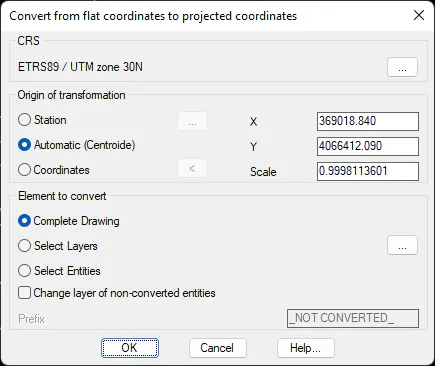
First of all, it is necessary to choose the CRS, and then the Origin of transformation, which can be:
Station. Selecting this option enables the button ... that allows you to choose an existing control point in the drawing.
Automatic (Centroid). This option, which is selected by default, proposes to use as the origin the coordinates of the centroid of the current drawing.
Coordinates. If this option is chosen, the X,Y coordinates of the origin to be used must be entered manually.
Elements to convert
Complete drawing. If this option is selected, you will try to apply the scaling factor to all draft entities.
Select Layers. This option allows you to select the layers to whose features the scaling factor will be applied.
Select Entities. If this possibility is chosen, after pressing the OK button, the designation of the entities to be modified will be requested.
Change layer of non-converted features. If this check box is selected, features in the drawing that could not be processed are changed to a layer named after the original, preceded by the value of the Prefix check box.
The complementary command is Projected to Planar.