
tcp PointCloud Editor
Record linear path - PCE
11.8 Record Linear Path
Location
- Ribbon menu
- Imagery
- VIDEO
- Linear (Record Linear Path)
Description
This command generates a video of a route along an existing alignment or polyline.
To generate this kind of video, you also need a vertical alignment or a digital model (grid or surface).
Parameters
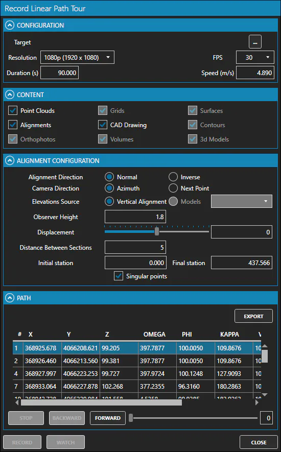
| Name | Meaning |
|---|---|
| Target | Destination video file, in which the generated video will be saved |
| Resolution | Resolution of the generated video |
| FPS | Frames per second |
| Duration (s) | Video duration in seconds |
| Speed (m/s) | Travel speed of the camera along the path in meters per second |
| Alignment Direction | Direction of travel along the alignment |
| Camera Direction | Direction in which the camera looks at each point |
| Elevations Source | Source data to determine elevation |
| Observer Height | Height of the camera with respect to the estimated elevation |
| Displacement | Lateral displacement of the camera with respect to the alignment |
| Distance Between Sections | Discretisation distance of the alignment to compute the waypoints |
| Initial Station | Point on the alignment where the route starts |
| Final Station | Point on the alignment at which the route ends |
| Singular Points | Checked if Singular Points must be included as waypoints |
How to use
-
Select either an alignment in the Project Panel or a single polyline from the CAD Drawing.
-
Click the "Record Linear Path" button in the ribbon menu.
-
Set the configuration parameters according to your needs.
-
Check the content options you want to render.
-
Set the alignment configuration parameters according to your needs.
-
Click the "RECORD" button to start generating the video.
-
In the RENDERING window that appears, you can modify the camera attitude as the video is generated, using the available controls.
Remarks
- You can export waypoints to file. This allows editing the waypoints in a text editor.