
tcpMDT
Station calculation - MDT25
25.8 Station Calculation
This option is used to perform the survey calculation and gives access to an important set of application options.
This dialog box's appearance depends on the user mode set in the Surveying Configuration. Consult how each of the controls works in the relevant sections.
Beginner Mode
In this mode, only the essential survey calculation controls are displayed. In order to access the other options, one should directly use the options menu.
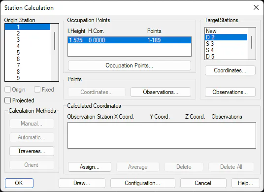
Origin Station. Allows one to select the station of origin. Once selected, the dialog box displays the instrument set-ups at this station, the stations and points read, as well as the coordinates calculated.
Origin. When this check box is activated, it indicates that the station should be considered as an origin in order to automatically calculate stations and points by clicking the appropriate button. See Automatic Calculation.
Fixed. If this option is activated, the station's coordinates will not be modified whichever calculation method used.
Projected. Activating this option indicates that the survey is not using plane coordinates, but one of the projections permitted by the application. See Survey Data command.
Occupation Points. Allows access to Occupation Points information.
The following options are found in the Points box:
Observations. Allows access to the Points Observations information.
Coordinates. Allows access to the Point Coordinate information.
The following options are found in the Stations box:
Stations. Displays a list of the stations read from the origin station. Double clicking on New allows one to enter a new station observation from that origin station.
Observations. Allows access to the Station Observations information.
Coordinates. Allows access to the Station Coordinates information.
The following options are available in the Calculation Methods box:
Automatic. See Automatic Calculation.
Manual. See Manual Calculation.
Orient. The program assigns the horizontal correction calculated from the station and observed stations when the Orient button is clicked.
Traverses. See Traverses.
The Calculated Coordinates box displays the coordinates calculated from the station of origin. See Calculated Coordinates.
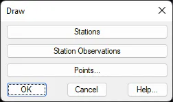
The Draw button displays the current survey's stations, points and station observations by clicking the relevant button.
Lastly, the Configuration button allows access to Surveying Configuration.
Advanced Mode
This mode can be used to calculate points and stations, and additionally gives access to other calculation methods and more advanced options.
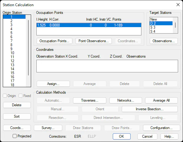
Origin Station. Allows one to select the station of origin. Once selected, the dialog box displays the instrument set-ups at this station, the stations and points measured, as well as the coordinates calculated.
Origin. When this check box is activated, it indicates that the station should be considered as an origin in order to automatically calculate stations and points by clicking the appropriate button. See Automatic Calculation.
Fixed. If this option is activated, the station's coordinates will not be modified whichever calculation method used.
Delete. Deletes the origin station from the survey file. All the associated observations are also deleted, so confirmation is requested before this action can take place.
Sort. Modifies the representation order of the origin stations. It can be in alphabetical or numerical order, and the original file order is lost.
Coords. Allows access to the Station Coordinates information.
Projected. Activating this option indicates that the survey is not using plane coordinates, but one of the projections permitted by the application. See Survey Data command.
The options set out below can be found in the Occupation Points box:
Occupation Points. Allows access to Occupation Points information.
Point Observations. Allows access to the Points Observations information.
Coordinates. Allows access to the Point Coordinate information.
The following options can be found within the Target Station box:
Stations. Displays a list of the stations read from the origin station. Double clicking on New allows one to enter a new station observation from that base station.
Observations. Allows access to the Station Observations information.
The Calculated Coordinates box displays the coordinates calculated from the station of origin. See Calculated Coordinates.
The following options are available in the Calculation Methods box:
Automatic. See Automatic Calculation.
Traverses. See Traverses.
Networks. See Networks.
Average All. This button averages all coordinates at each station in a similar way as the Average button.
Manual. See Manual Calculation.
Orient. Clicking this button causes the program to assign a horizontal correction to the actual instrument set-up. This correction is calculated from the origin and target station coordinates.
Inverse Bisection. See Inverse Bisection.
Resection. See Resection.
Direct Intersection. See Direct Intersection.
Levelling. See Trigonometric Levelling.
Some additional buttons are to be found at the bottom of the dialog box:
Survey. See Survey Data command.
Draw Stations. Draws the stations and their observations. See Draw Stations and Draw Station Observation commands.
Draw Points. See Draw Points command.
Configuration. Allows access to the Surveying Configuration.
Lastly, there is a status line displaying the state of the corrections used on the bottom line of the dialog box, so that they can be easily consulted. The initials of those that are activated will be displayed as enabled, among the following:
Code Description
ATM Atmospheric
ESR Sphericity and Refraction
RHO Reduction to Horizon
RNM Reduction to Sea Level
ELP Reduction to Ellipsoid
AAP Instrument Angle
Calculated Coordinates
The central part of the dialog box contains a list of the possible station coordinates that displays information about their origin and the calculation method used. These allow one to have an overview of the magnitude of the errors and reminds one how the calculation process was executed. The current coordinates of the station are the ones selected in this list.
The list's first field, Observation St., displays which station allowed the calculation of the current station. The last field named Observations shows the method, which could be any of the following:
Name Description
Direct Assignment Coordinates assigned directly to the station
Database Coordinates obtained from an imported stations file
Change Coord. Change of coordinates
Compensation Network compensations
Drawing Coordinates obtained from drawn stations
Direct Int. Direct Intersection
Inverse Int. Inverse Intersection
Double Observation Station calculation using forward and backward observations
Simple Observation Station calculation using one-way measurements only
Traverse Traverse compensation
Average Coordinate averaging
Projected transformation Plane to projected coordinate transformation
In addition to these observations, the text "and Levelling" may appear after the code. This indicates that the X and Y station coordinates have been calculated by one method, and the elevation calculated by levelling. This gives one a great deal of control over the way in which the calculations have been performed.
Below the list of possible station coordinates, the program indicates the maximum distance errors (eD), and coordinate errors (eX, eY and eZ). These values are the maximum differences between all the alternatives for any station.
Clicking the Average button assigns the station an average value from all the possible station coordinates. If one wishes to delete any of the possibilities, Delete should be clicked. For example, if they are considered to be unreliable. If one wishes to delete all of them for any station, Delete All should be clicked.
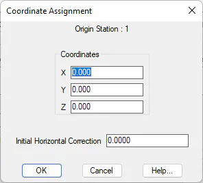
Lastly, the Assign button allows one to directly input coordinates and the initial instrument set-up's initial horizontal correction.
Automatic Calculation
By clicking the Automatic button in the Station Calculation command, the program calculates the whole survey using various methods. For this to be possible, the measurements must be taken from a station having assigned coordinates and marked as an origin.
The following algorithm is used:
First, the program examines all the occupation points containing direct circle and inverse circle observations, so as to assign the angle corrections due to the instrument accuracy (CH.Ap and CV.AP).
Then starting with the current occupation point and following the order in which the files appeared, all the stations containing return (forth and back) observations are calculated.
Subsequently, all the one-way observation stations are calculated in the same order as above.
For stations that could not be calculated as above, the direct intersection method and then the resection method are attempted.
The process is repeated until all stations have been calculated, or until no more can be calculated from the available data.
Once the process is completed, the program displays an on-screen report showing the errors obtained.
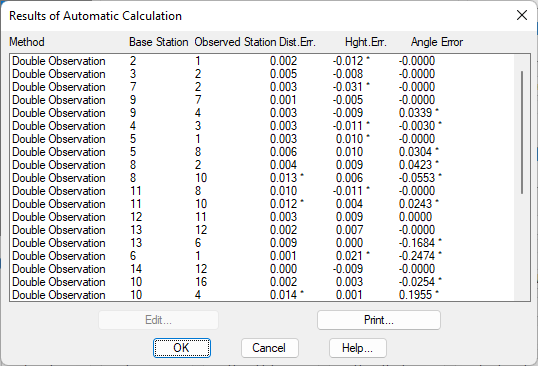
This window displays the calculation method used, the target and origin stations, distance errors, as well as the height and angle obtained . An asterisk to the right of the value indicates that it falls beyond the configuration tolerance set. If a line from the list is selected and Edit button clicked or if the line is double clicked, the program displays the observations between stations and allows one to modify them.
Manual Calculation
The Manual button allows one to calculate the stations one by one after having previously selected the origin station in the window to the left of the dialog box and the target station from the target stations list. This method is useful when there are several ways to calculate the stations and it is preferable to the automatic calculation method.
If a backward observation to the origin station exists, the program displays a window containing information about the distances and elevation difference used in the calculation, in addition to the resulting original correction. Clicking the Edit button allows one to modify the observation data.
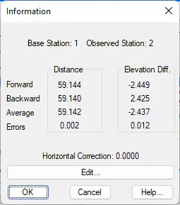
If, on the other hand, there is no backward observation, the target station coordinates are calculated and the origin station is changed in the dialog box.
If one clicks the OK button, the coordinates and the horizontal correction to the current instrument set-up are applied.