tcpMDT
Export to GeoPDF - MDT26
 | Command to execute in the CAD |
|---|---|
Vertical menu | MDT26 > GIS > ExportGeoPDF |
Ribbon menu | |
Command line |
Export to GeoPDF
This MDT command allows you to generate a GeoPDF file from a CAD drawing. It only exports the visible layers of the drawing. It shows a small dialog with options to generate the GeoPDF.
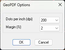
We can change the points per inch or the drawing margin within the PDF sheet.
The result will be a raster GeoPDF file, georeferenced and with only 3 layers, DXF Entities, Texts and Images, which can be toggled on or off by the user.
Related videos