
tcpMDT
Label Attributes - MDT26
 | Command to execute in the CAD |
|---|---|
Vertical menu | MDT26 > GIS > Label attributes |
Ribbon menu | GIS > Utilities > Label Attributes |
Command line |
Label Attributes
With this command, we can label in the drawing a specific attribute belonging to a layer generated from the Import GIS command, at any time.
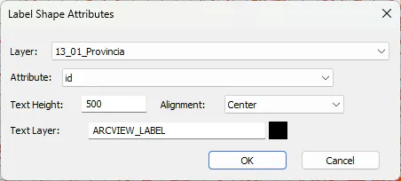
Layer: Dropdown list with all layers with attributes in the drawing.
Attribute: Dropdown list with all attributes of the selected layer.
Text height: Text height that will be used for labeling in the drawing.
Alignment: Position of the labeled text in the drawing.
Text layer: Name and color of the layer where texts will be drawn.