
tcpMDT
[PRO] Calculate Points by Station and Offset - MDT26

Calculate Points by Station and Offset
 | Command to execute in the CAD |
|---|---|
Vertical menu | MDT26 > Setting Out > Calculate Points by Station and Offset |
Ribbon menu | Setout > Analysis and Set-out > Calculate Points |
Command line |
This command helps one to calculate a point related to a horizontal alignment. The command initially requests if the values are to be keyed in or read from a File. In the latter case, it requests a file (with .PKD extension) having a two-column format: the first column contains the stations and the second contains the offsets, separated by one or more spaces. The file does not have to be in column format.
The horizontal alignment is the selected either graphically or through a file, with the possibility of selecting a segment. Once the file is requested, the program then requests Station and Offset continuously until the user presses . The last offset is repeated by default.
Additionally, if a segment has been selected, the program will request Layer Thickness. This value will be subtracted from the elevation resulting from the setting out and is always positive.
MDT performs a calculation process with the above-mentioned data and displays a list containing the following information on each line: station and offset (input data), X, Y and Z coordinates, as well as the azimuth and radius corresponding to the horizontal alignment at that station. Any station outside the horizontal alignment's limits will be ignored. The Z coordinate is obtained from the digital model, should it be defined. If a segment is selected, the Z coordinate will correspond to the grade line having the layer thickness applied.
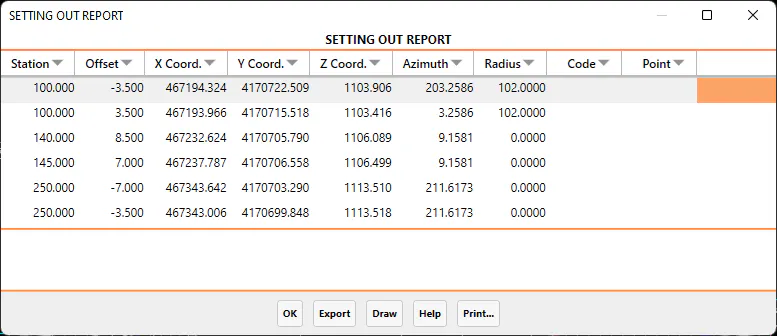
It is possible to export and print the data obtained from the final list. A description of each of the options follows:
Export
When the Export option is selected, the program displays a new dialog box with different ways of exporting the data. The dialog box and a description of its characteristics appear below:
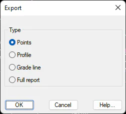
Points: All the coordinates of all the points on the list are exported to a points file. When the dialog box is validated, the Export Points command is automatically executed. For further details, see the Points section.
Profile: Creates a longitudinal profile from the information in the list generated.
Grade line: Similar to the previous option, only in this case it creates a grade line without curves.
Full report: This option transfers the complete list to a text file.
When this option is selected, the data listed is sent to the printer selected.