
tcpMDT
[PRO] draw compound long section - MDT25
9.20 [PRO] Draw Compound Long Section

Presents a segment on screen (see Segments commands), that is to say, the possibility of drawing a complete profile containing all the information on grade line, superelevations, long sections, curvatures, etc. If one only wishes to draw the terrain, the Profiles > Draw Simple Long Section command should be used.
Once the command is executed, it will ask us for the file of segments to draw. There is the possibility of drawing several segments simultaneously, this would prevent us from executing the command successively for each of the segments to draw.
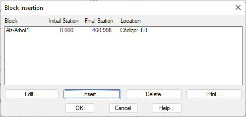
Therefore, if we select several segments in the same folder, the following window will appear, in which we can manage the files to draw.
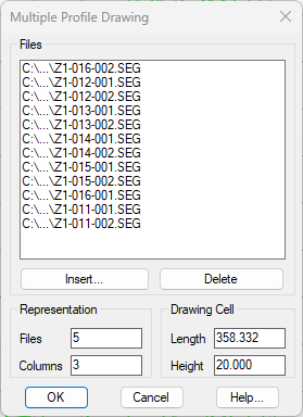
TcpMDT will calculate the most optimal distribution in Rows and Columns, as well as the space reserved, both in Length and Height for the drawing of each segment, however, it can be customized.
Additionally, with the Insert and Delete buttons. Later, we have the possibility to add more segment that could be located in another folder, or delete some from the list because we do not want to draw it.
After validating this window, the following dialog will appear in which we will manage the parameters for the drawing of the segment.
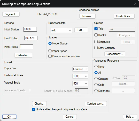
Drawing
Initial station: Initial station from which one wishes the drawing to be made. By default, it has the lowest station value of the selected profile.
Final Station: Station up to which one wishes to draw the profile on screen. By default, it is the profile's maximum station.
Title: Once the profile is drawn, the title entered will appear on the top of the drawing.
Initial Profile: Represents the initial profile to be represented in the Profile Numbering element previously defined in the numerical data (see Definition of Numerical Data).
Numerical Data
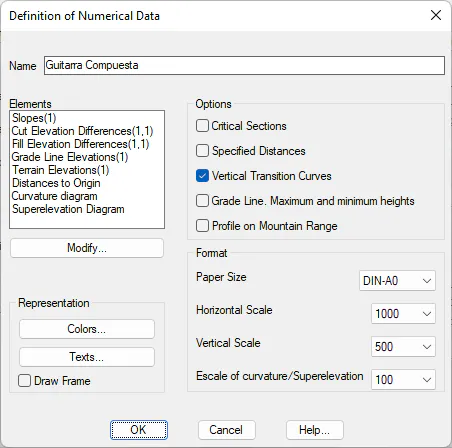
We select the numerical data associated with the profile that is to be represented; the dropdown menu offers the different numerical data defined by the user:
Edit: To edit the active numerical data with the possibility to make any modifications.
Next, we can see the dialogue box that appears when editing the numerical data. Its function and characteristics are described in the Definition of Numerical Data section.
Spaces
If Space* Model*** is selected, the profile drawing will be drawn normally, that is from the initial point selected on screen.
Should Paper Space be selected, it will be drawn using the paper space presentations available in CAD. This option is not available in some CAD engines.
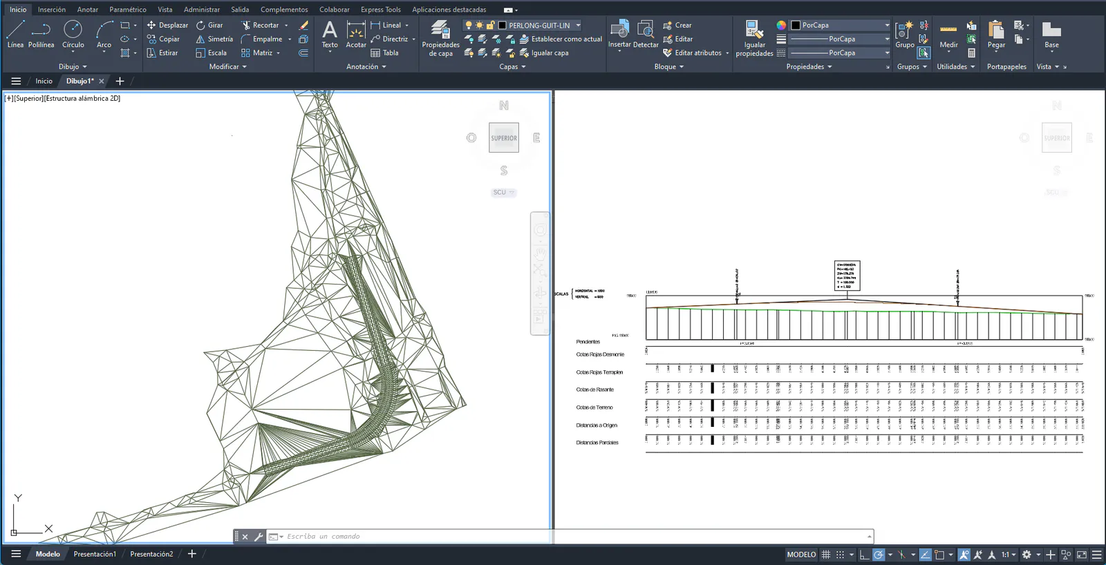
Draw in a different window: If this option is activated, it will allow us, using the viewports tool, to render in two windows. In this way, in one of them the drawing will be displayed with the current zoom, before the representation of the segment, and in the other window the longitudinal profile with the associated grade will be presented.
Options
Title: Once the profile is drawn, the title entered will appear on the top of the drawing.
Blocks: This option allows one to select the blocks one wishes to draw on the long section. At the same time, the Blocks numerical data element should be defined in the numerical data definition to be used
If the Configuration button is clicked, the following window is displayed where the insertion point of each of the blocks one wishes to insert along with the long section should be specified.
The following dialog box is displayed to insert or modify blocks for the long section drawing.
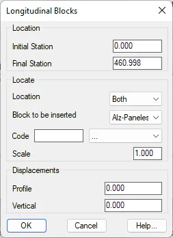
Everything concerning the definition and management of blocks is explained in greater detail in the Blocks Definition section.
Blocks: This option only serves a purpose in the event a series of structures has been assigned to the template type. As such, if we activate this option a block will be drawn in the initial and final station of each structure. The block to be inserted may be selected.
Cartography: This option will allow us to visualize the cartography on the long section drawn. This option is available only when the drawing is done in a particular sheet format.
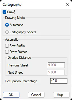
It has the following configuration parameters:
-
Draw: If this option is enabled, we activate the representation of the cartography.
-
Drawing Mode
-
Automatic: The cartography to be inserted will be calculated automatically according to the size of the selected sheet.
-
Cartography Sheets: If this option is selected, the previously defined sheets will be projected in the profile drawing with the command Long Section > Drawing > Draw Cartography Sheets.
In the case of selecting the Automatic option, the following parameters would be considered for the drawing of the cartography.
Saw Profile: The polyline that represents the long section. In the event that it does not have space for the drawing, will be drawn in sections, changing the comparison plane.
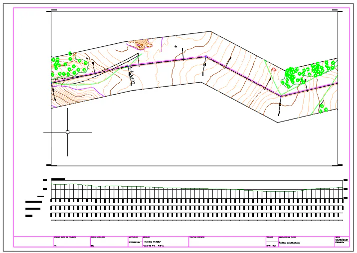
Draw Frames: Each section of cartography drawn on each sheet is drawn on a frame where the actual coordinates of the sheet are specified. In the image below, you can see the drawing of the frame.
Overlap Distances. With this option we get the leaves to overlap with each other a certain length.
Occupation Percentage: Percentage that the cartography will occupy in the selected paper format.
Structures: Activating this option will provide us with the possibility of drawing a block in the stations featuring an initial or final structure. Consult the template type section for information on the definition of structures.
Draw Catenary: Activating this box will draw the power cables associated with the long section. The numerical data on the "electricity lines" will be configured by default. On validating the dialog box, the command will ask the user for the file containing the information on the power lines.
Profile Length: This control will only be activated if the drawing is made on hard copy, in which case MDT will calculate the maximum length that can be drawn on each sheet depending on its format. The possibility exists of modifying this distance to adjust or give more margin to the representation.
Format
Paper Size: This check box is used to select the size of the paper. One can choose among the different formats contemplated for sheet distribution (defined in the ESCALAS.DAT file). If one does not wish to split the drawing, the Continuous option (default value) should be selected.
The option exists of modifying the formats proposed regarding their names, size and contents. In order to do so, the blocks in the BLOQUES/FORMATOS folder of the program's root directory should be modified.
Concerning scale fields, it is necessary to consider that the drawing's scale is determined by text size in CAD, as the drawing is only generated in a scale of 1:1 and proportionally to the horizontal / vertical relation.
Horizontal Scale: This drop-down list displays all the scales defined in the ESCALAS.DAT file in the MDT configuration directory. It is possible to complete the list with other usual values.
Vertical Scale: Same as the previous paragraph. The possibility of defining a vertical scale on the cross-section drawings has been thought up to make it possible to observe height differences in very long profiles having very small height differences without having the need to continuously enlarge the drawing on screen.
If a sheet format is selected by the scale command, the number of sheets needed for the long section drawing can be viewed.
Vertices to Represent
When a long section is represented, a series of vertices are represented. In this section one selects the vertices to be represented and the interval with which they are to be represented. Different options exist, which are described below.
None: No cut is represented on the profile's horizontal alignment. Only the long section will appear with the numerical data lines, without any text lettering.
All: Represents all the cuts in the long section.
Interval: Represents the longitudinal cuts at constant intervals.
Codes: Only represents those cuts where the codes selected are present. These are selected by clicking on the Select button.
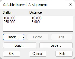
Variable: It will allow us to represent certain intervals between stations. In the next figure it will be represented every 10 meters up to station 100 and every 5 meters up to station 250.
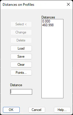
Distances: We introduce a certain distance in which we want to generate the presentation. Several options are available for the introduction of these distances.
Numerical Data
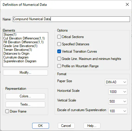
The type of numerical data to be represented on the long section drawing is edited here. The MDT.GTR numerical data file is selected by default. To change the default numerical data file, one must access configuration (see Customization Manual).
The dialog box that is displayed when numerical data is edited can be seen below. Its characteristics and the way it works are described in the Numerical Data Definition section.
Terrain
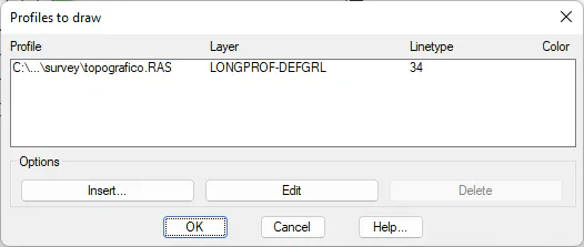
It is possible to draw several long sections at the same time on a same comparison plan with this option. If this button is selected, the long section initially selected will appear by default. As many long sections as, one wishes to add to the representation can then be inserted. The window shown below is then displayed when this command is activated:
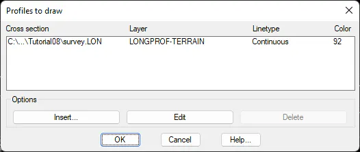
As you can see, you have the option of configuring the Layer, Line Type and representation Color of the corresponding long section.
Grade Lines
Several grade lines can be drawn simultaneously on the same comparison plan using this option. If this button is clicked, the grade line initially selected will appear by default. As many grade lines as one wishes to add to the representation may then be inserted. The window shown below is then displayed when this command is activated:
Ordinates
This option controls the representation of both the comparison plan and separation in ordinates. When this button is clicked, the following window is displayed, which is described below:
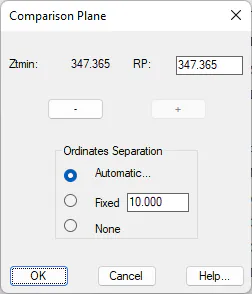
Comparison Plan: MDT proposes the comparison plan's height (it can be seen with the text Ztmin) by default. Its height can be changed by using the + or - buttons. The height increases or decreases when these buttons are clicked are directly related to the vertical scale selected on the numerical data.
Ordinate Separation: This control sets the separation of ordinates or, in other words, terrain elevation marks. Three different options exist:
Automatic: Depending on the drawing's scale, the program sets a suitable separation.
Fixed: The interval with which the terrain heights should be represented is set.
None: No information is displayed on terrain height ordinates.
Settings
Clicking on this tab accesses the settings for the long section, where, among other parameters, we can change the style of the presentation of the numerical data from among the different styles available. Consult the Customization Manual for further details.