
tcpMDT
[PRO] generate superelevations from cross sections - MDT25
13.16 [PRO] Generate Superelevations from Cross-Sections

The same as the previous command, this option generates a superelevation, but instead of the usual practice of using a horizontal alignment, this option enables generating the superelevation from the information existing of the cross-sections.
The command will analyze the vertices of each previously indicated cut and from the slope in regard to the position of the horizontal alignment of each one of them it calculates the left and right superelevation.
The first thing it requests is the cross-section file from which to generate the superelevation, then the following window is displayed to manage how the new superelevation file will be built.
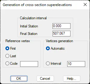
Calculation interval. Used to indicate between which stations the superelevation will be calculated.
Reference Vertex: Used to indicate the reference vertex of the cross-section to serve as a reference in generating the superelevation. There are three possibilities:
-
The first vertex on both sides from the position of the horizontal alignment.
-
The last vertex on both sides from the position of the horizontal alignment.
-
The first vertex on each side existing from the position of the horizontal alignment and in which its code coincides with the specified one in this option.
Vertices Generation: A superelevation vertex will be generated for each cross-section cut or according to the interval specified.
Once the window is validated it will request the superelevations file in which to save the information.
Generating Superelevations from Drawing 
This command will be very useful if we need the superelevation file and only have the elevation mode drawing of the superelevation.

The command will ask for the following information for the generation of superelevation files:
-
Superelevation drawing alignment: This is the brown line in the image above.
-
Left superelevation: The line representing the left superelevation, represented by the blue line in the image above.
-
Right superelevation: The line representing the right superelevation, represented by the green line in the image above.
Finally, the program will ask us for the superelevation file in which the information is to be saved.