
tcp PointCloud Editor
Selection by csf (cloth simulation filter) - PCE
7.14 Selection by CSF (Cloth Simulation Filter)
Location
- Ribbon menu
- Editing
- SELECT
- By CSF (Selection by CSF)
- SELECT
- Editing
Description
The Cloth Simulation Filter (CSF) is a ground filtering algorithm that simulates a cloth dropping onto an inverted point cloud to approximate the terrain surface. By “draping” a virtual cloth over the inverted data, the algorithm identifies the underlying ground surface. Points that lie within a specified vertical distance from this simulated cloth are classified as ground, while others are marked as non-ground. This method is versatile and effective for a range of environments—from rugged, densely vegetated mountains to urban areas with flat land and tall buildings. This filter will select all non-ground points.
Parameters
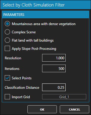
| Name | Meaning |
|---|---|
| Mountainous area with dense vegetation | Suitable for filtering rugged terrains with heavy vegetation, ensuring the cloth adapts to irregular surfaces. |
| Complex scene | Recommended for environments with mixed natural and man-made features; adjusts to varying ground characteristics. |
| Flat land with tall buildings | Ideal for urban areas, where the ground is mostly flat but buildings and structures may interfere with point classification. |
| Apply Slope Post-Procesing | Boolean option to enable additional slope correction, refining classification on inclined or uneven surfaces. |
| Resolution | Controls the density of the simulated cloth grid. Lower values yield finer detail by increasing the cloth node density. |
| Iterations | Number of simulation iterations allowed for the cloth to settle; higher values can improve accuracy in complex terrains. |
| Select Points | If checked, will select all non-ground points. |
| Classification Distance | Maximum vertical distance from the cloth surface at which points are considered ground. This threshold is crucial for accurate separation. |
| Import Grid | If checked, it will import to the project the simulated cloth model as a Grid. This allow to use grid editing tools to correct the theorical ground and improve the selection on complex scenarios. |
Use cases
- Ground filtering: Separate ground points from non-ground points.
- Ground classification: Generate digital terrain models (DTMs) by classifying the point cloud into ground and non-ground components.