tcpMDT
Draw Slope Arrow Map - MDT26
Draw Slope Arrow Map
 | Command to execute in the CAD |
|---|---|
Vertical menu | MDT26 > Maps > Draw Slope Arrow Map |
Ribbon menu | Maps > Maps > Slope Arrows |
Command line |
This command draws an arrow for each triangle of the current surface. An arrow's direction indicates the triangles lowest vertex.
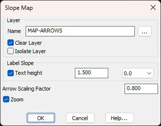
As can be seen, the options available are the same as for any other mapping command. The Arrow Scale Factor parameter multiplies by the triangle's size before serving as a scale to insert the arrow. The value 1 indicates that the arrows would fill the entire height of the triangle.
Label Slope: This option will allow us to label the slope text for each of the arrows. You can set the height of the texts to be labeled, and the number of decimals to be used.
The arrows drawn correspond to insertions of the bloques\flecha.dwg block located in the program installation directory. This block can be edited or replaced by another, considering that its size must be equal to one for the scaling to work correctly.