
tcpMDT
Holes filling - MDT26
 | Command to execute in the CAD |
|---|---|
Vertical menu | MDT26 > Maps > Hydrology > Holes Filling |
Ribbon menu | Maps > Hydrology > Fill Depressions |
Command line |
This command pre-processes a digital terrain model (DTM) by eliminating spurious depressions — closed areas with no hydrological outlet — that would prevent the correct layout of the drainage network. The result is a hydrologically conditioned surface where water can flow without being trapped in artificial local minima elevations.
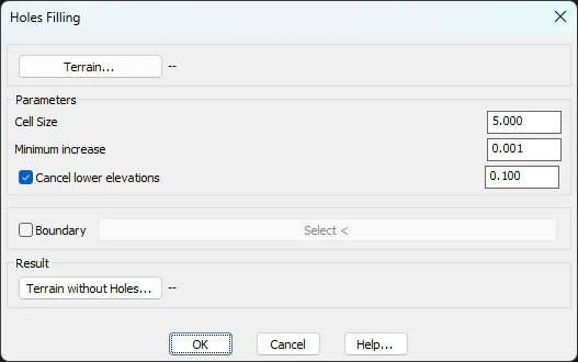
The Terrain... button allows you to select the input surface to the process. If you select a triangulated surface, you can set the pixel size of the internal raster generated for analysis in the Cell Size parameter. A lower value increases the accuracy but also the calculation time. When a regular mesh is selected, the dimension of the mesh cell is used. The Minimum increase is the minimum elevation difference that is forced between adjacent cells to ensure that the flow always has a defined direction, and to avoid flat areas with no slope. The option to Cancel lower elevations is used to override elevations close to 0, on models near the sea. Optionally, you can designate a Boudary by designating a polyline, applying the process to a specific area, instead of doing it on the entire model.
By default, the program proposes a new file to store the result of the process. By pressing the Terrain without Holes... button you can change the name of the file, which will be one of the input data for the next steps of the hydrological analysis: calculation of the flow direction, extraction of the drainage network, and calculation of basins.