
tcpMDT
[PRO] Copy Terrain to Vertical Alignment - MDT26

Copy Terrain to Vertical Alignment
 | Command to execute in the CAD |
|---|---|
Vertical menu | MDT26 > Vertical Alignments > Utilities > Copy Terrain to Vertical Alignment |
Ribbon menu | V.Alignments > Create > Convert Terrain |
Command line |
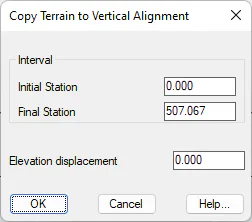
This command allows one to create a vertical alignment parallel to the terrain represented by a long section that already exists on the drawing. One is initially requested to select the terrain (by default the green polyline on the PERLONG-TERRAIN layer). The program then requests the Initial Station and Final Station (by default, 0 and the length of the profile respectively). Lastly it requests the Elevation Displacement, where one can enter values lower than zero in the case of a downward interval, or greater than zero in the case of an upward interval.
The opposite option is Copy Vertical alignment to Terrain.