
tcpMDT
[PRO] Copy Vertical Alignment to Terrain - MDT26

Copy Vertical Alignment to Terrain
 | Command to execute in the CAD |
|---|---|
Vertical menu | MDT26 > Vertical Alignments > Utilities > Copy Vertical Alignment to Terrain |
Ribbon menu | V.Alignments > Utilities > Copy to Terrain |
Command line |
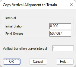
Initially, one is requested to graphically select a vertical alignment. The long section file to be created is then selected. The dialog box then requests the Initial Station and Final Station (with the default values being the values at the ends of the vertical alignment), in addition to the Interval to discretize the vertical transition curves.
Both this option and its opposite are particularly useful for partially or totally processing the theoretical vertical alignments designed, which can be used as future current conditions to design underground conduits.